
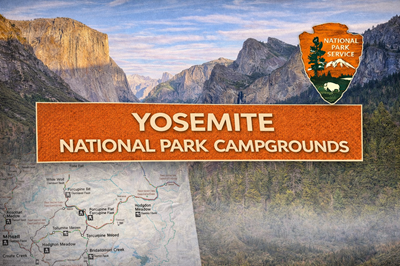
This PDF is a Yosemite National Park campground overview map, designed to give users a clear, high-level understanding of where camping areas are located across the park and how they connect to major roads and regions. Unlike detailed site maps, this document focuses on geographic distribution and access, helping visitors plan where to stay based on travel routes and seasonal availability.
The map (single page) outlines the entire park boundary and highlights major regions such as Yosemite Valley, Tuolumne Meadows, Hetch Hetchy, and Wawona. Campgrounds are marked with icons and labeled throughout the park, showing how they are spread across both central and more remote areas. As seen on the map, many campgrounds—like White Wolf, Porcupine Flat, and Tuolumne Meadows—are located along Tioga Road, which runs east–west across the park at higher elevations. Others, such as Bridalveil Creek and Wawona, are positioned along southern access routes.
A key feature of this map is its emphasis on seasonal accessibility. Several roads, including Tioga Road and Glacier Point Road, are clearly marked as closed during winter months. This directly impacts campground availability, with many sites labeled “open seasonally.” As a result, the map communicates that Yosemite’s camping options are heavily influenced by elevation and weather, and that access can change significantly depending on the time of year.
The map also illustrates how transportation routes shape camping logistics. Campgrounds are clustered along major roads, with limited options deep in the backcountry unless hiking is involved. Yosemite Valley appears as a central hub, while outlying campgrounds require longer drives and more planning. This reinforces that movement within the park is road-dependent, and that distances, terrain, and closures must all be considered when choosing a campsite.
Overall, this PDF serves as a strategic planning map for campground selection, rather than a detailed navigation tool. It helps users understand where campgrounds are located, how they relate to major park features, and when they are accessible. For preppers or outdoor users, it highlights important realities: seasonal road closures, limited access routes, elevation-driven conditions, and the need to plan lodging and movement carefully in a mountainous environment where availability and accessibility can shift throughout the year.
© Prepping Communities. This content is for informational purposes only and not professional advice. Use at your own risk.
Terms | Privacy | Guidelines