
This collection of PDFs , , , and together provide a highly detailed and practical overview of Canyonlands National Park, with a strong emphasis on backcountry navigation, terrain awareness, and route planning. These documents focus primarily on two major districts of the park—Island in the Sky and The Needles—each offering very different landscapes and challenges for hikers, backpackers, and off-road travelers.
The Island in the Sky maps (files 0 and 1) show a high plateau carved by the Colorado and Green Rivers into a maze of deep canyons. The backpacking zone map (file 0) divides the terrain into designated camping zones such as Upper West Basin, Gooseberry/Lathrop, and Murphy Point, helping visitors understand where backcountry camping is permitted. The trails and roads map (file 1) adds another layer of usability, clearly outlining paved roads, high-clearance 4WD routes like the White Rim Road, and hiking trails leading to major viewpoints such as Mesa Arch, Grand View Point, and Upheaval Dome. These maps highlight how access is limited and often requires careful planning, especially when venturing below the mesa top.
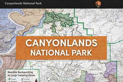
The Needles district maps (files 2 and 3) shift the focus to a more complex and rugged desert landscape filled with sandstone spires, narrow canyons, and interconnected trail systems. The Needles backpacking zones map (file 2) outlines areas like Salt/Horse Canyon, Davis/Lavender, and Butler/West Side Canyons, showing where dispersed camping is allowed. The Needles trails and roads map (file 3) provides extensive detail on hiking routes, including popular and challenging trails such as Chesler Park, Druid Arch, and Confluence Overlook. As noted in the trail descriptions on page 2, many routes involve slickrock, deep sand, steep climbs, and even ladders, making them physically demanding and requiring navigation awareness.
A consistent theme across all these PDFs is the harsh and resource-limited environment. The documents repeatedly emphasize that water is scarce or nonexistent on trails, and visitors must carry sufficient supplies. Roads are often rough or impassable without proper vehicles, and weather conditions—such as flash floods or extreme heat—can quickly turn dangerous. The maps also show how the park is divided into remote zones with limited infrastructure, reinforcing the importance of preparation, permits, and route planning.
Overall, these PDFs function as both navigation tools and survival-oriented guides. They provide a clear understanding of terrain, elevation changes, access routes, and camping zones while also highlighting the risks and challenges of exploring Canyonlands. For hikers, adventurers, or preppers, they offer valuable insight into operating in a rugged desert environment where self-reliance, planning, and situational awareness are essential.
© Prepping Communities. This content is for informational purposes only and not professional advice. Use at your own risk.
Terms | Privacy | Guidelines