
These PDFs together provide a comprehensive look at Black Canyon of the Gunnison National Park in Colorado, combining natural history, visitor guidance, and detailed mapping into a cohesive resource. These documents highlight one of the most dramatic and rugged landscapes in the United States, where the Gunnison River has carved a steep, narrow canyon through ancient rock over millions of years.
The main brochure (file0) focuses heavily on the geological and natural significance of the canyon. It explains how the canyon was formed through a combination of uplift and erosion, with the Gunnison River cutting through extremely hard crystalline rock over roughly two million years. The visuals on page 1 emphasize the canyon’s defining features—its steep walls, extreme depth, and narrow width—showing areas like the Painted Wall, which rises over 2,000 feet. The text also brings the environment to life by describing the sounds, wildlife, and plant life found throughout the canyon, from bighorn sheep and peregrine falcons to pinyon-juniper woodlands and mosses clinging to shaded rock faces.
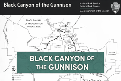
The brochure also provides practical visitor information. The second page outlines how to explore the park, including access points like the South Rim and North Rim, camping options, hiking routes, and safety considerations. It emphasizes the rugged and often dangerous nature of the terrain—warning about steep descents, loose rock, extreme heat, and the need for permits in the inner canyon wilderness. The map on this page shows roads, overlooks, trails, and key facilities, helping visitors plan their route and understand the park’s layout.
The second PDF (file1) complements this by offering a simplified, high-contrast map of the park. It clearly marks major features such as the Gunnison River route, overlooks, hiking trails, ranger stations, and access roads. This map is particularly useful for navigation and orientation, showing how the South Rim and North Rim are separated and how routes connect to key viewpoints and trailheads. It also highlights backcountry routes and areas requiring more advanced planning.
Together, these PDFs provide both context and usability: one explains the story and environment of the canyon, while the other provides a practical tool for navigating it. For outdoor enthusiasts, hikers, or preppers, they offer valuable insight into terrain challenges, elevation changes, water access, and route planning in a remote and demanding environment.
© Prepping Communities. This content is for informational purposes only and not professional advice. Use at your own risk.
Terms | Privacy | Guidelines