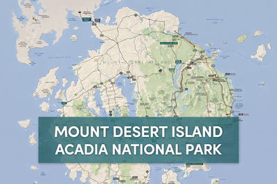
The map in represents Acadia National Park, located on Mount Desert Island along the rugged coastline of Maine. This area is one of the most iconic natural landscapes in the northeastern United States, where dense forests, granite mountains, freshwater lakes, and dramatic ocean cliffs all converge in a relatively compact region. The map highlights the park’s diverse terrain, showing how inland features like Jordan Pond, Eagle Lake, and Cadillac Mountain connect seamlessly to the surrounding Atlantic shoreline, bays, and smaller offshore islands.
One of the most notable features shown on the map is Cadillac Mountain, which rises to 1,530 feet and is the highest point on the U.S. East Coast. Surrounding it are a network of smaller peaks such as Dorr Mountain, Champlain Mountain, and Sargent Mountain, creating a rugged interior that is ideal for hiking and exploration. The map clearly outlines the Park Loop Road, a scenic route that winds through many of the park’s most famous viewpoints, including Sand Beach, Thunder Hole, and Otter Point. This loop provides access to key trailheads, campgrounds, and visitor centers, making it the backbone of navigation for visitors.
The coastal features are equally prominent. The map shows Frenchman Bay, Eastern Bay, and Western Bay, along with numerous coves, harbors, and inlets such as Seal Harbor, Southwest Harbor, and Bass Harbor. These areas reflect the park’s maritime character, where tides, rocky shorelines, and ocean exposure shape the environment. Notations like “passable at low tide” and ferry routes to nearby islands emphasize the dynamic relationship between land and sea in this region.
In addition to roads and natural landmarks, the map includes practical details for navigation and planning. It marks carriage roads, hiking trails, campgrounds, picnic areas, parking, and visitor centers, as well as warnings such as low-clearance bridges and restricted areas. The legend and symbols on the map help users quickly identify key services and terrain types, while notes remind visitors that some adjacent lands are private and that specialized maps are recommended for hiking.
Overall, this map serves as both a navigational tool and an overview of Acadia National Park’s layout. It captures the balance between accessibility and wilderness, showing how roads and facilities are integrated into a landscape that remains largely natural and undeveloped. For preppers, outdoor enthusiasts, or travelers, it provides valuable insight into terrain, water sources, access routes, and potential shelter areas within one of the most scenic and strategically diverse parks in the region.