
The PDF is a detailed map and visitor guide for the National Park of American Samoa, located in the South Pacific. Unlike many mainland U.S. national parks, this park spans tropical islands and coastal ecosystems, offering a unique blend of rainforest-covered mountains, coral reefs, and traditional Samoan villages. The document combines both a localized town map and a broader island overview, making it useful for navigation, orientation, and understanding the region’s geography.
The first page of the PDF focuses on the local area around Pago Pago, Fagatogo, and Utulei villages on Tutuila Island. This section highlights everyday infrastructure and points of interest, including the National Park Visitor Center, bus stations, lodging, banks, markets, and coastal access points. The map uses clear symbols (legend on page 1) to identify essential services such as restrooms, food, police, and transportation, making it practical for visitors navigating the area. It also shows trails and cultural landmarks, including Blunts Point with World War II cannons and Rainmaker Mountain, giving insight into both the historical and natural significance of the region.
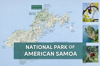
The second page expands outward to a full island map of Tutuila, showing the larger layout of the national park and surrounding environment. This view highlights key natural features such as coral reefs, rugged coastlines, volcanic terrain, and dense tropical forest. Landmarks like Pola Island, Fagatele Bay National Marine Sanctuary, and Fogama’a Crater are clearly marked, along with hiking trails, paved and unpaved roads, and authorized park areas. The map also indicates restricted or temporarily closed areas, helping visitors understand where access may be limited.
A notable aspect of this map is how it emphasizes the connection between land and ocean. The park is not just terrestrial—it includes protected marine environments, which are vital for coral reef ecosystems and marine life. The images along the side of page 2, such as coral reefs and fruit bats, reinforce the biodiversity of the area, showcasing species and habitats unique to this tropical region.
Overall, this PDF serves as both a navigational tool and an educational overview of the National Park of American Samoa. It provides a clear picture of how villages, infrastructure, and wilderness areas are interconnected, while also highlighting the park’s ecological diversity and cultural importance. For outdoor enthusiasts, travelers, or preppers, it offers valuable insight into terrain, resources, access routes, and environmental conditions in a remote island setting.
© Prepping Communities. This content is for informational purposes only and not professional advice. Use at your own risk.
Terms | Privacy | Guidelines