
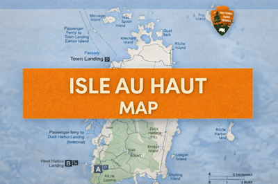
This PDF is a detailed map of Isle au Haut, a remote island that is part of Acadia National Park in Maine. It provides a clear geographic overview of the island, surrounding smaller islands, and key access points, serving as both a navigation tool and a planning resource for visitors traveling to this isolated coastal environment.
The map highlights the island’s rugged terrain and natural features, including named peaks such as Mount Champlain, Bowditch Mountain, and Duck Harbor Mountain. As seen on the map, elevations are relatively modest but still significant for an island environment, contributing to varied terrain that includes forested areas, rocky coastlines, and inland features like Long Pond. The southern portion of the island is shaded to indicate protected park land, emphasizing the preserved wilderness character of that area.
Access and transportation are a major focus of the document. The map clearly marks ferry routes and landing points, including year-round service from Stonington to Town Landing and seasonal ferry access to Duck Harbor. These details highlight how dependent the island is on marine transportation, reinforcing its remote and somewhat isolated nature. The surrounding waters are dotted with smaller islands such as Kimball Island, York Island, and Merchant Island, giving a sense of the broader coastal geography.
The map also identifies key points of interest and infrastructure, such as campgrounds, trails, and landing areas. The Duck Harbor area, in particular, is shown as a primary access point for visitors entering the national park portion of the island. Trails are indicated throughout the park section, showing how movement across the island is structured but still limited compared to more developed parks.
Overall, this PDF functions as a coastal navigation and orientation map, helping users understand both the layout of Isle au Haut and the logistics required to reach and explore it. It emphasizes the island’s combination of accessibility and isolation—reachable by ferry, yet still very much a quiet, rugged, and lightly developed wilderness destination.
© Prepping Communities. This content is for informational purposes only and not professional advice. Use at your own risk.
Terms | Privacy | Guidelines