
These PDFs together provide a detailed and practical overview of the Bartlett Cove area in Glacier Bay National Park & Preserve, focusing on campground layout, visitor infrastructure, and marine access. These documents work together as a compact field guide for navigating one of the primary access points into this remote Alaskan wilderness.
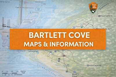
The Bartlett Cove Campground Area map (file0) gives a broad view of the developed area, including the Glacier Bay Lodge, visitor center, public dock, and campground. It highlights essential features such as trails, restrooms, food storage caches, and the intertidal zone, where cooking and eating are required to reduce bear encounters. The guidance on this page strongly emphasizes bear safety and food management, instructing visitors to store all scented items properly and avoid attracting wildlife. This reinforces the reality that even developed areas in Glacier Bay are still very much wild environments.
The campground-specific map (file1) zooms in further, showing individual campsites, tent platforms, outhouses, fire rings, and food cache locations. It provides a clear layout of how the campground is organized along the shoreline and connected by trails such as the Beach Trail and Forest Trail. This level of detail is especially useful for campers planning where to set up, how to access facilities, and how to move efficiently through the area while staying within designated paths.
The Bartlett Cove docking map (file2) shifts focus to marine access and infrastructure. It outlines the public use dock, fuel dock, boat ramp, and kayak storage areas, along with strict rules governing docking, time limits, and no-wake zones. As shown in the usage table on this page, different areas are designated for specific purposes—public docking, floatplanes, National Park Service vessels, and short-term loading zones. It also highlights services like potable water and marine sewage pump-out, while reinforcing restrictions such as no overnight parking and limited docking times.
Across all three PDFs, a consistent theme is controlled access within a remote wilderness setting. While Bartlett Cove provides critical infrastructure—camping, docking, and visitor services—it is still surrounded by vast, undeveloped terrain. The maps emphasize careful planning, adherence to rules, and respect for wildlife and environmental conditions.
Overall, these documents function as a combined navigation, logistics, and safety guide, helping visitors understand how to safely camp, travel, and access Glacier Bay by both land and water.
© Prepping Communities. This content is for informational purposes only and not professional advice. Use at your own risk.
Terms | Privacy | Guidelines