
Seeing the hidden networks that keep modern life running — and fail quietly when stressed
Most people experience infrastructure only when it works. Lights turn on. Water flows. Fuel appears at stations. Data moves invisibly. When something breaks, it feels sudden — but it almost never is.
Infrastructure and critical systems maps exist to show the skeleton of modern society: the networks that support daily life and the weak points where small failures cascade into large disruptions.
For preppers and homesteaders, these maps are not about paranoia or targeting systems. They are about situational awareness, risk reduction, and planning around fragility. Knowing where infrastructure concentrates — and where it doesn’t — helps you choose locations, routes, and strategies that fail more slowly and predictably.
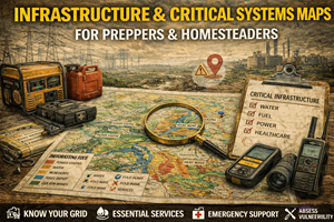
What infrastructure & critical systems maps actually show
Infrastructure and critical systems maps may include:
- electrical generation, transmission, and substations
- water treatment plants and major pipelines
- wastewater and sewer systems
- fuel pipelines, refineries, and terminals
- rail corridors and freight hubs
- ports and shipping lanes
- major data centers and fiber corridors
- hospitals and emergency service coverage
These maps don’t usually show every component — but they reveal patterns of dependence. They show where systems converge, overlap, and rely on single points of failure.
In preparedness terms, they answer questions like:
- Where does my power actually come from?
- How far does my water travel before it reaches me?
- What happens if this corridor goes down?
- How quickly would services degrade here?
- Which areas are resilient — and which are brittle?
Why infrastructure maps matter for preparedness
1) Most failures cascade, not isolate
Infrastructure systems are deeply interconnected. A disruption in one often triggers others:
- power loss affects water pumping
- water loss affects sanitation
- fuel shortages affect emergency response
- data outages disrupt coordination and commerce
Infrastructure maps help you see where cascading failure is likely, not just where something might break.
Preparedness improves when you anticipate secondary effects, not just the initial outage.
2) Centralization increases fragility
Modern systems are efficient — but efficiency often means centralization:
- fewer substations
- fewer treatment plants
- fewer fuel terminals
- just-in-time logistics
Infrastructure maps reveal where centralization creates:
- single points of failure
- large impact zones
- long recovery times
Prepared people prefer redundancy over efficiency.
3) Recovery time matters more than outage length
A brief outage is inconvenient. A prolonged outage reshapes daily life.
Infrastructure maps help you estimate:
- how many people depend on the same system
- how complex repairs will be
- how far replacement services must travel
Preparedness isn’t just about if something fails — it’s about how long you can live with it.
Why infrastructure maps are essential for homesteaders
Homesteaders often assume they are less dependent on infrastructure. In reality, most are still connected to:
- regional power grids
- fuel supply chains
- medical and emergency networks
- data and communications backbones
Infrastructure maps help homesteaders:
- identify realistic off-grid priorities
- decide which systems to disconnect from
- choose locations with fewer dependencies
- plan backups for unavoidable connections
True resilience is intentional independence — not accidental isolation.
Electrical grid maps: the most important layer
Power underpins nearly everything. Grid maps often show:
- generation sources
- high-voltage transmission lines
- substations and distribution hubs
These maps help identify:
- areas with frequent outages
- regions dependent on long-distance transmission
- places vulnerable to weather or wildfire
- neighborhoods at the “end of the line”
Preparedness planning without grid awareness is incomplete.
Water & wastewater systems: fragile and overlooked
Water infrastructure is often:
- aging
- centralized
- energy-dependent
Maps that show water treatment plants, reservoirs, and major pipelines help you understand:
- how far water travels
- where contamination risk concentrates
- how outages cascade into sanitation problems
For homesteaders, this reinforces the value of:
- independent water sources
- gravity-fed systems
- on-site treatment options
Fuel & transportation corridors: movement and energy combined
Fuel doesn’t magically appear at stations. It moves along:
- pipelines
- rail corridors
- shipping routes
- trucking hubs
Infrastructure maps reveal:
- choke points
- terminal locations
- regions with limited redundancy
During disruptions, fuel shortages appear first and worst near these constraints.
Understanding fuel geography helps you plan storage, timing, and alternatives.
Data & communications infrastructure: the invisible backbone
Modern preparedness discussions often overlook data infrastructure. Yet communications failures:
- slow emergency response
- fragment information
- disrupt coordination
- increase panic
Maps showing major data corridors, exchanges, and data center clusters highlight:
- areas with robust connectivity
- regions dependent on distant nodes
- places likely to lose service quickly
Preparedness means planning for communication degradation — not just power loss.
Real-world prepper use cases for infrastructure maps
Choosing resilient places to live
Your “best places to live” and general prepper maps gain depth when infrastructure fragility is considered:
- areas with decentralized systems
- regions with multiple supply routes
- communities with local services
Resilience often correlates with smaller scale, not remoteness.
Planning shelter-in-place strategies
Infrastructure maps help determine:
- how long utilities might remain available
- when to conserve resources
- when to transition to backups
Prepared people don’t wait for outages to become severe.
Validating bug-out decisions
Bugging out into an area dependent on fragile infrastructure may reduce safety, not increase it.
Maps help answer:
- Will fuel be available?
- Will water be accessible?
- Will roads remain functional?
Where to find infrastructure & critical systems maps (real sources)
Infrastructure data is often fragmented, but useful sources include:
United States
- U.S. Energy Information Administration (EIA) — power plants, transmission, fuel infrastructure.
https://www.eia.gov/maps/ - U.S. Department of Transportation (DOT) — freight and transportation corridors.
https://www.transportation.gov/data
Canada
- Natural Resources Canada (NRCan) — energy and resource infrastructure context.
https://natural-resources.canada.ca/ - Provincial open-data portals — often provide the most detailed local infrastructure mapping.
(Note: local government and utility open-data portals often provide the most actionable detail.)
Offline strategy for infrastructure awareness
What to keep offline
- grid and substation overview maps
- water and wastewater system diagrams
- fuel corridor maps
- major transportation routes
What to annotate
- single points of failure
- backup options
- areas with repeated outages
- places to avoid during disruptions
Infrastructure changes — revisit these annually.
Practice drills that build infrastructure literacy
Drill A: “Follow the system”
Trace your power, water, and fuel back to their sources. Count how many steps are involved.
Drill B: “Single-point failure test”
Ask:
- What happens if this one node goes down?
- How many people are affected?
- How long until repair?
Drill C: “Dependency audit”
List what you still depend on infrastructure for — then plan realistic backups.
Common mistakes with infrastructure maps
- Mistake: assuming outages are isolated
Fix: plan for cascading effects. - Mistake: overestimating repair speed
Fix: complex systems recover slowly. - Mistake: ignoring communications
Fix: loss of information worsens every crisis. - Mistake: equating remoteness with resilience
Fix: isolation can increase dependency.
How infrastructure maps connect to your Prepper Map Packs
Infrastructure maps provide the systems-awareness layer for your entire platform:
- best places to live
- bug-out locations
- general prepper maps
They help users understand which areas are supported by fragile networks — and which rely more on local capacity.
This reinforces a core theme of the series:
“Preparedness isn’t about escaping systems — it’s about knowing which systems you still depend on.”