
Identifying the places that quietly become traps when water rises
Flooding is one of the most common, most underestimated, and most disruptive hazards people face — and it doesn’t require coastal living or dramatic storms to happen. Floodplain and flood risk maps exist because water moves predictably, even when people don’t.
For preppers, flood risk maps are about avoiding routes that disappear, homes that become isolated, and evacuation plans that fail at the worst moment. For homesteaders, they are about not building tomorrow’s problems into today’s land choices.
Flooding doesn’t announce itself loudly. It creeps, spreads, undercuts, and isolates. Maps are how you see it coming before the road is gone.
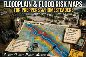
What floodplain & flood risk maps actually show
Floodplain and flood risk maps typically display:
- areas likely to flood during specific events (e.g., “100-year” or “500-year” floods)
- elevation-based flood zones
- river overflow areas
- coastal surge zones (where applicable)
- sometimes levees, dams, and flood control features
Despite the terminology, these maps do not mean floods happen only once every 100 years. They describe probability, not schedules. A “100-year floodplain” means there is a 1% chance of flooding in any given year — which can happen multiple times in a decade.
In preparedness terms, flood maps show:
- where water spreads when systems are stressed
- which roads fail first
- which neighborhoods become isolated
- which areas are safe only until conditions change
Why flood risk maps matter for preparedness
1) Flooding isolates before it destroys
Most flood-related harm happens before water enters buildings. Roads wash out. Low crossings disappear. Bridges close. Emergency services stop moving.
Flood maps help you identify:
- routes that become impassable early
- areas that turn into islands
- access points that disappear quietly
Preparedness isn’t just about staying dry — it’s about not being cut off.
2) People consistently underestimate water speed and force
Even shallow moving water can:
- sweep vehicles off roads
- undermine pavement
- collapse culverts
- erode shoulders
Flood risk maps reveal areas where water concentrates and accelerates. These are places people mistakenly drive into because they look “mostly fine” — until they’re not.
Maps turn invisible danger into visible logic.
3) Flooding compounds other failures
Flooding often coincides with:
- power outages
- sewage system failures
- contaminated water supplies
- fuel shortages
- delayed emergency response
Floodplain maps help you see where multiple risks overlap, not just where water appears.
Why flood maps are critical for homesteaders
Homesteaders don’t just pass through flood-prone areas — they live with them.
Floodplain awareness affects:
- house placement
- barn and livestock safety
- garden viability
- road and driveway design
- long-term erosion
- insurance and rebuilding costs
Many homesteaders inherit problems they didn’t cause simply because they didn’t consult flood maps before buying land.
A property that floods “once every few decades” is still a liability — especially as weather patterns shift and infrastructure ages.
The hidden flood risks people miss
Low crossings and culverts
Small creeks often cross roads through culverts that:
- clog with debris
- back up quickly
- wash out underneath pavement
Flood maps often reveal these problem areas better than road maps do.
Flat doesn’t mean safe
People assume flat land is safer than hills. In flood scenarios, flat land often:
- drains poorly
- collects water over wide areas
- stays saturated longer
Floodplain maps show that gentle terrain can flood worse than steep terrain.
Development changes flood behavior
Urbanization increases runoff. Paved surfaces push water faster into drainage systems that may already be stressed.
Flood maps help reveal:
- downstream effects of upstream development
- neighborhoods that flood “suddenly” because conditions changed upstream
This matters for both evacuation planning and homestead siting.
Flood maps and route planning (where plans really fail)
Preparedness plans often assume:
- roads remain usable
- detours are available
- emergency services can assist
Flood maps challenge those assumptions.
They help you identify:
- roads that flood before rivers visibly rise
- routes that follow drainage basins
- “shortcuts” that become dead ends
- bridges that close early as a precaution
Knowing this ahead of time allows you to choose routes that stay functional longer — or decide not to move at all.
Real-world prepper use cases for flood risk maps
Planning evacuation timing
Flood maps help determine:
- how early you need to move
- when staying put becomes safer than leaving
- which direction offers higher ground
Timing matters more than speed.
Choosing safer staging areas
If you need to shelter temporarily, flood maps help you avoid:
- low basins
- valley floors
- areas downstream of dams or levees
A “safe-looking” spot at night can be a problem by morning.
Where to find floodplain & flood risk maps (real sources)
United States
- FEMA Flood Map Service Center (FMSC) — official flood hazard maps by address or area.
https://msc.fema.gov/ - FEMA National Flood Hazard Layer (NFHL) — downloadable flood risk data for deeper planning.
https://www.fema.gov/flood-maps/national-flood-hazard-layer
Canada
- Natural Resources Canada Flood Hazard Identification and Mapping Program (FHIMP) — national flood mapping initiative with provincial partnerships.
https://natural-resources.canada.ca/science-data/science-research/natural-hazards/flood-mapping/flood-hazard-identification-mapping-program - Provincial flood mapping portals (availability and detail vary by province).
(Important note: local flood mapping is often more accurate than national summaries — always check regional sources.)
Offline strategy for flood maps
What to keep printed
- floodplain map for your home area
- flood risk map for primary travel routes
- maps showing low crossings and river valleys
What to annotate
- roads that flood first
- bridges that close early
- areas that become isolated
- safe high-ground alternatives
Review these notes after major storms — conditions change.
Practice drills that build flood awareness
Drill A: “Wet weather drive”
After heavy rain (safely), observe:
- where water pools
- which roads look marginal
- which areas drain slowly
Compare what you see with flood maps.
Drill B: “Route survival test”
Pick a planned route and ask:
- What happens if water rises 2 feet?
- Where do I get trapped?
- What’s my escape before that point?
Drill C: “Upstream thinking”
Identify upstream features that could worsen flooding:
- development
- burn scars
- dams or retention ponds
Common mistakes with flood maps
- Mistake: assuming flooding is rare
Fix: treat flood risk as probability, not history. - Mistake: trusting GPS during storms
Fix: GPS routes often ignore flood logic. - Mistake: building or staging in low ground
Fix: elevation matters more than convenience. - Mistake: assuming insurance equals safety
Fix: insurance doesn’t prevent isolation.
How flood maps connect to your Prepper Map Packs
Flood risk is a filter, not an afterthought.
Your curated maps for:
- bug-out locations
- best places to live
- survive-off-the-land regions
…become far more trustworthy when flood exposure is explicitly considered.
This belongs clearly in the series:
“Preparedness isn’t just choosing good locations — it’s eliminating locations that fail quietly under stress.”