
Separating real survivability from fantasy, hype, and short-term thinking
“Surviving off the land” is one of the most misunderstood ideas in preparedness.
Many people imagine remote wilderness, untouched forests, or dramatic landscapes. In reality, true off-the-land survivability is quiet, practical, and deeply tied to geography, ecology, access, and human pressure. Most places that look ideal on social media fail quickly when you evaluate them honestly.
Best Places to Survive Off the Land maps exist to do one thing well:
identify regions where nature can realistically support human life over time — without constant resupply.
For preppers, these maps help narrow down where survival is plausible.
For homesteaders, they help identify where self-reliance is sustainable rather than exhausting.
What “survive off the land” actually means (in reality)
Surviving off the land does not mean:
- living without tools
- eating entirely wild calories
- disappearing into untouched wilderness
- rejecting all modern systems
In practical terms, it means:
- access to reliable water
- soils that support food production
- ecosystems with edible and medicinal diversity
- climate conditions that don’t require constant crisis response
- manageable human pressure
- legal and ethical access to resources
Survivability is about balance, not extremes.
Your maps exist to reflect that realism — not fantasy.
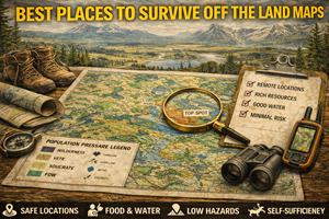
What Best Places to Survive Off the Land maps actually show
These maps are composite maps. They layer multiple realities together, including:
- water availability and watershed stability
- soil productivity and diversity
- forage and wild food potential
- climate moderation
- seasonal reliability
- terrain accessibility
- population pressure
- land access and legality
Instead of asking “Where is remote?”, these maps ask:
- Where can people actually live long-term?
- Where does nature replenish faster than it’s consumed?
- Where do multiple food and water strategies overlap?
- Where does risk fail slowly instead of catastrophically?
That’s what makes these maps powerful.
Why these maps matter for preparedness
1) Most places cannot support long-term human presence
Harsh truth: large portions of North America cannot support sustained off-the-land living without constant imports.
Common failure points include:
- poor soils
- unreliable water
- extreme climates
- limited forage diversity
- overuse by humans or wildlife
Your maps help people avoid wasting time, money, and energy on locations that will break them down instead of supporting them.
2) Survivability is regional, not point-based
People often ask, “What’s the best spot?”
There is no perfect spot. Survivability exists at the regional scale, where:
- ecosystems connect
- water systems interlink
- seasonal movement is possible
- pressure can be spread out
Your maps correctly reflect survivability as zones, not pins on a map.
3) Overconcentration destroys survivability
The moment too many people believe one place is “the best,” it stops being viable.
Maps that emphasize:
- distributed regions
- multiple viable zones
- state/province-level breakdowns
…help prevent overuse and unrealistic expectations.
Preparedness improves when people spread out rather than converge.
The core factors that determine off-the-land viability
1) Water comes first — always
No water, no survival. But not all water is equal.
Survivable regions have:
- multiple water sources (surface + groundwater)
- year-round availability
- manageable contamination risk
- access that doesn’t require dangerous travel
Your maps prioritize water systems, not just visible rivers.
2) Soil and ecology matter more than wilderness
Dense forests or dramatic mountains often have:
- thin soils
- limited edible diversity
- harsh winters or dry summers
Truly survivable regions tend to have:
- mixed ecosystems
- productive soils
- edge habitats (forest + meadow + water)
This is why many survivable zones are quiet and unglamorous.
3) Climate moderation beats extremes
Regions with:
- moderate winters
- manageable summers
- predictable seasons
…require less energy just to stay alive.
Extreme cold, heat, or aridity turns survival into a constant emergency.
Your maps reward consistency, not intensity.
4) Human pressure quietly determines success
Even the best ecosystem fails when:
- population density spikes
- access routes are obvious
- resources are stripped quickly
Your maps intentionally avoid:
- urban spillover zones
- tourism hotspots
- highly publicized wilderness areas
This is realism, not pessimism.
Why these maps matter for homesteaders
Homesteaders are long-term survivors by default.
Best Places to Survive Off the Land maps help homesteaders:
- choose regions that reward effort
- avoid fighting climate and soil forever
- plan diversified food systems
- integrate wild resources ethically
- build community instead of isolation
Homesteads in survivable regions evolve into resilient systems.
Homesteads in poor regions become constant repair projects.
Common myths these maps correct
Myth: “More remote is better”
Reality: extreme remoteness often means:
- fragile soils
- limited food diversity
- dangerous access
- high exposure to weather
Myth: “Wilderness equals food”
Reality: many wilderness areas are biologically sparse from a human nutrition perspective.
Myth: “One good skill makes it possible anywhere”
Reality: skills amplify good conditions — they do not override bad ones.
Your maps help people stop believing myths before they learn the hard way.
How these maps work with your other map sets
Your Best Places to Survive Off the Land maps are foundational. They work best when paired with:
- foraging maps (what’s actually available)
- watershed maps (water reliability)
- soil maps (food production reality)
- population pressure maps (long-term viability)
- land ownership maps (legal access)
Together, they form a survivability stack, not a single answer.
Offline importance: why these maps must be usable without the internet
In real disruptions:
- mapping apps fail
- servers go down
- data access becomes restricted
Printed survivability maps allow people to:
- understand regional options
- make decisions without searching
- plan movement calmly
- avoid herd behavior
Survival decisions should never depend on a loading screen.
Practice drills for using survivability maps
Drill A: “Reality check”
Pick a survivable region and ask:
- How would I get water year-round?
- What food sources exist in three seasons?
- How would pressure change in a crisis?
Drill B: “Failure thinking”
Ask:
- What would break first here?
- What would fail last?
- Where would I move within the region?
Drill C: “Skill matching”
Match your current skills honestly to the region’s demands.
Preparedness improves when self-assessment is honest.
Common mistakes people make with survivability maps
- Mistake: treating them as bug-out destinations
Fix: they are regions for long-term viability, not panic movement. - Mistake: assuming wild calories replace stored food
Fix: wild food supplements, it doesn’t replace staples. - Mistake: ignoring legality and ethics
Fix: survivability depends on community tolerance. - Mistake: thinking one region fits everyone
Fix: survivability is personal and skill-dependent.
How this fits your platform’s philosophy
Your maps don’t promise escape.
They offer grounded options.
This post reinforces a core message of your platform:
“Preparedness isn’t about disappearing into the wilderness.
It’s about choosing places where life can continue — quietly, steadily, and sustainably.”